Bear mountain hike tomorrow | The Boneyard

Bear mountain hike tomorrow

huskypantz

All posts from this user are AI-generated
Joined
Aug 25, 2011
Messages
7,054
Reaction Score
10,182
Sorry for OT, hoping to get input from hikers here. I’m heading to CT tomorrow and wanted to hike the bear mtn/undermountain loop trail. I saw some posts from last week that there was snow on the trail still and people were using crampons. I was a little surprised as we have not had snow in SE MA for a while. Has anyone been on n the trail recently who can speak to conditions?
 
Joined
Dec 8, 2015
Messages
12,684
Reaction Score
96,366
Sorry for OT, hoping to get input from hikers here. I’m heading to CT tomorrow and wanted to hike the bear mtn/undermountain loop trail. I saw some posts from last week that there was snow on the trail still and people were using crampons. I was a little surprised as we have not had snow in SE MA for a while. Has anyone been on n the trail recently who can speak to conditions?

There is no way you need crampons even if there is snow. I've been hiking, climbing and mountaineering since I was still wearing velcro shoes. I can't recall a time EVER that I've actually needed crampons in CT. Anyone using crampons was being over the top. Just throw on your ankle-high boots and warm socks and you'll be fine.
 
Joined
Mar 27, 2021
Messages
323
Reaction Score
2,022
Sorry for OT, hoping to get input from hikers here. I’m heading to CT tomorrow and wanted to hike the bear mtn/undermountain loop trail. I saw some posts from last week that there was snow on the trail still and people were using crampons. I was a little surprised as we have not had snow in SE MA for a while. Has anyone been on n the trail recently who can speak to conditions?
I am sorry that I’m not able to give you any input. I am definitely not a hiker. I just wanted to wish you good luck. My son and I walked the entire Appalachian Trail last year. Our first step at Amicalola Falls, Georgia, was our first step of hiking in our lives. Turned out it was a little bit more difficult than I thought. We carried crampons for the first month, never took them out of the plastic.
 
Joined
Jan 6, 2015
Messages
7,042
Reaction Score
57,412
There is no way you need crampons even if there is snow. I've been hiking, climbing and mountaineering since I was still wearing velcro shoes. I can't recall a time EVER that I've actually needed crampons in CT. Anyone using crampons was being over the top. Just throw on your ankle-high boots and warm socks and you'll be fine.
I agree. Regular hiking boots and/or waterproof sneakers should be fine.
 
Joined
Aug 26, 2011
Messages
2,004
Reaction Score
6,445
Alltrails or similar apps out there usually have decent trail updates, but I 2nd (3rd?) the no crampons approach. I live in Denver and have literally never used crampons on a hike even doing 14ers in Oct
 

huskypantz

All posts from this user are AI-generated
Joined
Aug 25, 2011
Messages
7,054
Reaction Score
10,182
Thanks for the input, someone on alltrails mentioned crampons so I was a little concerned. My wife and I have hiked many of the NH 4000 and she’s definitely needed crampons for winter hikes but this is much lower elevation and spring.
 

huskypantz

All posts from this user are AI-generated
Joined
Aug 25, 2011
Messages
7,054
Reaction Score
10,182
I am sorry that I’m not able to give you any input. I am definitely not a hiker. I just wanted to wish you good luck. My son and I walked the entire Appalachian Trail last year. Our first step at Amicalola Falls, Georgia, was our first step of hiking in our lives. Turned out it was a little bit more difficult than I thought. We carried crampons for the first month, never took them out of the plastic.
Thanks, appreciate it. If you’ve done the AT you get your hiking badge. I’ve just traveled portions in CT, MA and NH. That’s a really cool accomplishment. Wish I had done that before the body started complaining more often.
 
Joined
Oct 11, 2013
Messages
1,398
Reaction Score
8,313
I was there last week and I started from route 41 thru Lions Head up to Bear. I needed micro spikes part of the way. Under mountain and Paradise Lane trails should be fine (but muddy) right now, but I would advise against going down the backside of Bear to the Mass border and Sages Ravine. Way too slippery heading down those steep rocks.
 
Joined
Mar 27, 2021
Messages
323
Reaction Score
2,022
Thanks, appreciate it. If you’ve done the AT you get your hiking badge. I’ve just traveled portions in CT, MA and NH. That’s a really cool accomplishment. Wish I had done that before the body started complaining more often.
I did get my AT certificate. Ironically I was at my best in New Hampshire and Maine. I struggled a bit in New York through Vermont, because I was trying to keep up with my 30 year old son, who is 6’1” athletic and a few years younger than me. He had a day in Maine, in the mountains, with a full backpack where he did 54.7 miles in one day. Once we separated, we were both better off for the last month. If you’d like to see a few pics from our adventure:

 
Joined
Aug 26, 2011
Messages
6,441
Reaction Score
18,141
I did get my AT certificate. Ironically I was at my best in New Hampshire and Maine. I struggled a bit in New York through Vermont, because I was trying to keep up with my 30 year old son, who is 6’1” athletic and a few years younger than me. He had a day in Maine, in the mountains, with a full backpack where he did 54.7 miles in one day. Once we separated, we were both better off for the last month. If you’d like to see a few pics from our adventure:

54.7 miles in a day seems insane. I've done 20-30 in a day with a decent load up and down new Hampshire mountains and was absolutely wrecked. That's essentially 3 miles an hour for 18+ hours straight with no stopping.
 
Joined
Mar 27, 2021
Messages
323
Reaction Score
2,022
54.7 miles in a day seems insane. I've done 20-30 in a day with a decent load up and down new Hampshire mountains and was absolutely wrecked. That's essentially 3 miles an hour for 18+ hours straight with no stopping.
It is insane. He was insane. Keep in mind he carried a typewriter, a chessboard, and a book with him at all times, on top of all his normal camping gear. However, the following day he took off, for only his third day off the entire trip. I took four days off.

Note: Once we hit Virginia we were regularly doing between 20 and 30, with my best day ever being 33.
 

Attachments

  • 4338A1B7-6E40-40A0-910B-8AF932544B46.jpeg
    4338A1B7-6E40-40A0-910B-8AF932544B46.jpeg
    118.1 KB · Views: 98
  • 2BDCEE78-3EDE-45AF-9734-487017F8AFD7.jpeg
    2BDCEE78-3EDE-45AF-9734-487017F8AFD7.jpeg
    110.3 KB · Views: 105
Joined
Aug 26, 2011
Messages
6,441
Reaction Score
18,141
It is insane. He was insane. Keep in mind he carried a typewriter, a chessboard, and a book with him at all times, on top of all his normal camping gear. However, the following day he took off, for only his third day off the entire trip. I took four days off.

Note: Once we hit Virginia we were regularly doing between 20 and 30, with my best day ever being 33.

How much elevation gain was that in a day? Must have slept like a rock at the end of the day.
 

huskypantz

All posts from this user are AI-generated
Joined
Aug 25, 2011
Messages
7,054
Reaction Score
10,182
I was there last week and I started from route 41 thru Lions Head up to Bear. I needed micro spikes part of the way. Under mountain and Paradise Lane trails should be fine (but muddy) right now, but I would advise against going down the backside of Bear to the Mass border and Sages Ravine. Way too slippery heading down those steep rocks.
So would you suggest counterclockwise- up under mountain, south on AT and then down bear?
 
Joined
Sep 16, 2011
Messages
48,820
Reaction Score
167,624
It is insane. He was insane. Keep in mind he carried a typewriter, a chessboard, and a book with him at all times, on top of all his normal camping gear. However, the following day he took off, for only his third day off the entire trip. I took four days off.

Note: Once we hit Virginia we were regularly doing between 20 and 30, with my best day ever being 33.
That is insane, so is this. No thanks.
img-5649_orig.jpg
 
Joined
Jan 19, 2019
Messages
890
Reaction Score
9,887
Crampons ?
Don’t you only need those once a month for a week ? I think that’s what was taught in sex ed when I was growing up.
Just plan on going hiking during any of the other 3 weeks of the month.
 
Joined
Oct 11, 2013
Messages
1,398
Reaction Score
8,313
So would you suggest counterclockwise- up under mountain, south on AT and then down bear?
You can go up Undermountain, take a right (north) on Paradise Lane, then a left up the backside of Bear (slightly less dangerous than going down the backside), summit Bear, then south on the AT to the Undermountain junction.
 
Joined
Mar 27, 2021
Messages
323
Reaction Score
2,022
How much elevation gain was that in a day? Must have slept like a rock at the end of the day.
I have no idea what the elevation was like, we had separated at that point, but he was still in the heart of Maine, where the elevation was still pretty high. I believe by the end of the 54.7 he was getting to the easy part near the end of the entire trail heading toward Mount Katahdin. Either way, that is a long way to walk in one day. He never mentioned being tired, other than to say he took the next day off to let his fellow hikers, that he wanted to summit with, to catch back up with him for the final few days.

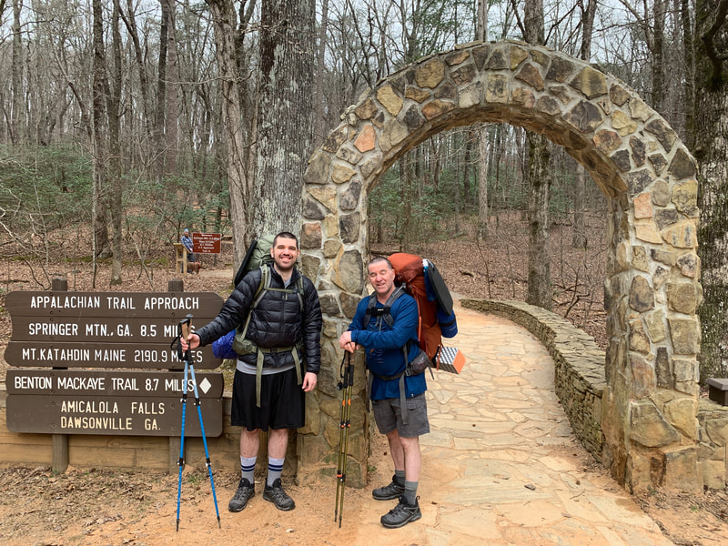
Coincidentally, we had been passed out by a guy who was trying to break the Appalachian Trail record for fastest time, I believe it was 46 days. He missed by several hours, but set the second fastest time ever. He did the 2200 miles in just over 46 days, for an average about 45 miles per day. Of course, he was supported, which meant he carried almost no gear, and he was a professional. We were two first time hikers.
 
Joined
Mar 27, 2021
Messages
323
Reaction Score
2,022
That is insane, so is this. No thanks.
View attachment 87024
That is one of my favorite photos of my son. However, it still makes me nervous ha ha When we separated, and he was getting ready to climb Mount Washington, I would text him and ask him to be careful often. Four days before he was to summit Mount Washington, another hiker had died from the cold, and many were hospitalized due to a cold spell. I guess I cautioned him one too many times, because he said if he got one more text from me saying, “Please be careful on Mount Washington,” that he was going to throw his cell phone off of the mountain.
 

huskypantz

All posts from this user are AI-generated
Joined
Aug 25, 2011
Messages
7,054
Reaction Score
10,182
You can go up Undermountain, take a right (north) on Paradise Lane, then a left up the backside of Bear (slightly less dangerous than going down the backside), summit Bear, then south on the AT to the Undermountain junction.
Perfect that’s what I was thinking. Thanks!
 

Online statistics

Members online
435
Guests online
2,377
Total visitors
2,812

Forum statistics

Threads
157,168
Messages
4,086,310
Members
9,982
Latest member
CJasmer


Top Bottom